Luftbilder | 2017 | Flug Salt Lake City - Seattle
Alle 175 Aufnahmen der Bilderserie 2017 | Flug Salt Lake City - Seattle auf einer Webseite.
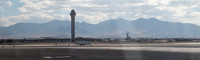
Salt Lake City International Airport
Im Hintergrund die Wasatch Range.
Flug Salt Lake City - Seattle.
| Abend (evening) | Architektur (architecture) | Atmosphäre (atmosphere) | Atmosphärisches Phänomen (Atmospheric phenomenon) | Bedienung (service) | Berg (mountain) | Düsenflugzeug (jet aircraft) | Fahrzeug (vehicle) | Fluggesellschaft (airline) | Flughafen (airport) | Flugplatz (airfield) | Flugreisen (air travel) | Flugzeug (aircraft) | Flugzeug (airplane) | Foto (photograph) | Gebäude (building) | Gebirgszug (mountain range) | Großstadt (metropolis) | Himmel (sky) | Hochland (highland) | Horizont (horizon) | Infrastruktur (infrastructure) | Kontrollturm (control tower) | Kumulus (cumulus) | Luft- und Raumfahrttechnik (aerospace engineering) | Luftfahrt (aviation) | Metall (metal) | Meteorologische Erscheinung (meteorological phenomenon) | Öffentlicher Verkehr (public transport) | Runway (runway) | Stadt (city) | Stadt (town) | Stadtgebiet (urban area) | Städtisch (urban) | Tagsüber (daytime) | Transport (transportation) | Turm (tower) | Verkehrsflugzeug (airliner) | Verkehrsmittel (mode of transport) | Wolke (cloud) |
Luftbilder
Flug DAL1873 Salt Lake City (KSLC) - Seattle/Tacoma (KSEA)
Salt Lake City International Airport
Wasatch Range
Haben Sie am gezeigten Bild Interesse oder suchen Sie ein bestimmtes Bild, so setzen Sie sich bitte über den Link Feedback / Kontakt mit mir in Verbindung.
Die auf ERDE IN BILDERN gezeigten Aufnahmen sind hochaufgelöste Digitalbilder oder Dias, die in sehr hoher Auflösung digitalisiert wurden.
Technische Bilddaten:
Kamera:
Canon PowerShot G7 X
Film:
DIGITAL
ISO:
125
Brennweite:
15.2 mm (41.4 mm KB)
Zeit:
1/1250 sec.
Blende:
f/6.3
Koordinaten:
111.975° West / 40.7692° Nord