Luftbilder | 2017 | Flug Salt Lake City - Seattle
Alle 175 Aufnahmen der Bilderserie 2017 | Flug Salt Lake City - Seattle auf einer Webseite.
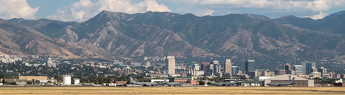
Salt Lake City International Airport, Downtown (City Center)
Links das Utah State Capitol Building. Im Hintergrund die Wasatch Range.
Flug Salt Lake City - Seattle.
| Atmosphäre (atmosphere) | Atmosphärisches Phänomen (Atmospheric phenomenon) | Berg (mountain) | Buntheit (Colorfulness) | Draußen (outdoors) | Ebene (plain) | Fabrik (factory) | Foto (photograph) | Gebäude (building) | Gebirgige Landformen (mountainous landforms) | Gebirgszug (mountain range) | Gegend (neighborhood) | Geologie (geology) | Großstadt (metropolis) | Grundstück (property) | Grundstück (land lot) | Hochhaus (tower block) | Hochland (highland) | Höhenzug (ridge) | Horizont (horizon) | Hügel (hill) | Immobilie (real estate) | Kumulus (cumulus) | Landschaft (landscape) | Landschaft (scenery) | Metropolregion (metropolitan area) | Natur (nature) | Natürliche Umgebung (Natural environment) | Raffinerie (refinery) | Stadt (city) | Stadt (town) | Stadtgebiet (urban area) | Städtisch (urban) | Tagsüber (daytime) | Wahrzeichen (landmark) | Welt (world) | Wohngebiet (residential area) |
Luftbilder
Flug DAL1873 Salt Lake City (KSLC) - Seattle/Tacoma (KSEA)
Downtown (City Center)
Salt Lake City International Airport
Utah State Capitol Building
Wasatch Range
Haben Sie am gezeigten Bild Interesse oder suchen Sie ein bestimmtes Bild, so setzen Sie sich bitte über den Link Feedback / Kontakt mit mir in Verbindung.
Die auf ERDE IN BILDERN gezeigten Aufnahmen sind hochaufgelöste Digitalbilder oder Dias, die in sehr hoher Auflösung digitalisiert wurden.
Technische Bilddaten:
Kamera:
Canon PowerShot G7 X
Film:
DIGITAL
ISO:
200
Brennweite:
36.8 mm (100.1 mm KB)
Zeit:
1/1250 sec.
Blende:
f/7.1
Koordinaten:
111.975° West / 40.7692° Nord